
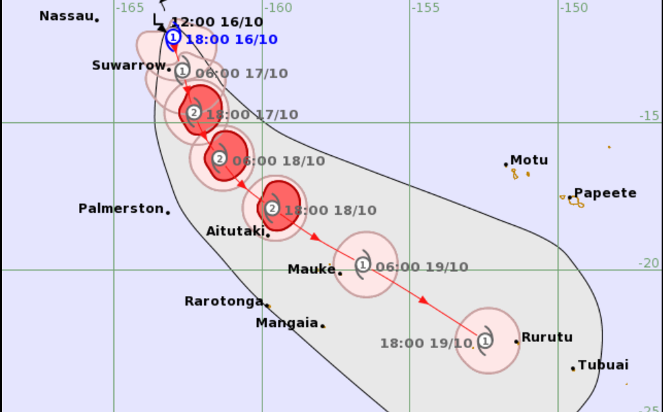
An out-of-season tropical cyclone has formed in the South Pacific, with Tropical Cyclone Wati strengthening to a Category 1 system and tracking towards the Cook Islands.
The Regional Specialised Meteorological Centre (RSMC) in Nadi confirmed that Tropical Cyclone Wati was located near 12.1 degrees south and 163.0 degrees west at 6am Fiji time today, October 17.
The cyclone had a central pressure of 994 hectopascals and was moving southeast at approximately 15 kilometres per hour.
Wati has formed outside the official South Pacific tropical cyclone season, which runs from November 1 to April 30.
According to RSMC Nadi, the system is intensifying, with sustained winds near its centre estimated at 40 knots, or approximately 74 kilometres per hour.
These winds are expected to strengthen to 60 knots, or about 111 kilometres per hour, by 6am tomorrow, October 18.
The forecast track shows Wati moving southeast through the Cook Islands region, with the system expected to strengthen to Category 2 as it approaches areas near Suwarrow and Aitutaki.
The projected path places the cyclone near 13.2 degrees south and 162.7 degrees west by 6pm today, before reaching 14.7 degrees south and 162.3 degrees west by 6am tomorrow.
The forecast map indicates that Wati could remain a Category 2 cyclone through October 18 before weakening as it continues southeast towards French Polynesia.
The cyclone’s formation in October is unusual, although tropical cyclones can develop outside the official season when atmospheric and ocean conditions are favourable.
RSMC Nadi has requested all vessels within 300 nautical miles of the cyclone’s centre to submit weather reports every three hours to assist monitoring and forecasting.
The system is not forecast to directly affect Fiji, but its development is being monitored by RSMC Nadi, which provides tropical cyclone forecasting services for the southwest Pacific region.