Part 2
In the Pacific, rain is never just weather; it is life, sustenance, and sometimes a sudden, overwhelming force. You can smell it on the trade winds long before it arrives—that unmistakable, earthy scent of petrichor rising off the warm soil as heavy cumulonimbus clouds darken the horizon.
Yet, for all its familiar presence, quantifying liquid water from the sky is one of meteorology’s greatest logistical challenges. How do we turn a torrential tropical downpour or a persistent drizzle into exact millimetre records that farmers, hydrologists, and disaster managers can trust?
Following our look at the wind, this second part of our series explores the essential instruments that capture the Earth’s most vital fluid, tracing water from the open clouds down to the rain gauge and into our climate archives.
Simple catchment gauges
At its most fundamental level, measuring rain requires a reliable container and a graduated cylinder. Standard rain gauges used across meteorological networks are essentially open-ended cylinders designed with a precise funnel area to catch rainwater while preventing loss from splashing or evaporation.
When a shower passes, the collected water is poured into a narrow measuring tube where even a fraction of a millimetre becomes visibly magnified.
While deceptively simple, these manual gauges have served island communities for generations, providing the crucial baseline data needed to understand local microclimates and seasonal water availability without relying on complex electronics.
Tipping-bucket mechanics
To capture rainfall in real time—especially during remote operations or fast-moving storms—meteorologists rely on the ingenious tipping-bucket rain gauge. Inside a cylindrical housing, rainwater funnels down into a tiny, balanced see-saw dual bucket mechanism.
Once exactly 0.2 millimetres (or 0.01 inches) of rain fills the active side, the weight tips the bucket over, dumping the water out the bottom while simultaneously moving the second bucket into place.
Each physical “tip” triggers a tiny magnetic reed switch that sends an electrical pulse to a data logger or telemetry transmitter. This transforms continuous rainfall into an instantaneous stream of digital data, letting forecasters track downpour intensity minute by minute.
Weighing the storm
In heavy tropical squalls or long-duration monsoonal events, standard tipping buckets can sometimes under-report intense rainfall rates because water splashes out or drains too quickly during extreme peaks. To solve this, high-precision climate stations utiliSe weighing-bucket precipitation gauges.
Instead of counting tips, the entire catchment bucket sits atop a sensitive mechanical scale or load cell. As rain accumulates, the total weight increases continuously, recording every drop regardless of whether it falls as light mist, heavy rain, or even melting hail. This continuous weight curve provides a foolproof historical trace of accumulation over hours and days.
Liquid versus solid
While rainfall is our primary tropical concern, global precipitation encompasses solid forms like snow, sleet, and ice pellets in higher latitudes or high altitudes.
Measuring solid precipitation requires heated gauge attachments that melt frozen water as it falls so it can pass through the standard measuring mechanism.
For climatologists tracking global water cycles, knowing the water equivalent of solid precipitation is just as vital as measuring tropical rain. Unheated gauges left to catch snow would quickly clog and freeze, missing critical accumulation data entirely during cold-weather events.
Overcoming wind errors
One of the greatest hidden enemies of accurate rain measurement is the wind. When strong winds blow across an open weather station, they create swirling eddies around the top of a rain gauge, blowing light droplets or fine rain sideways and drastically underestimating the true catch.
To combat this aerodynamic error, professional rain gauges are surrounded by specialized wind shields—such as the Alter shield, featuring a ring of freely swinging metal slats that deflect approaching wind downward and smooth the airflow over the instrument opening. Without these shields, high-wind storms like tropical cyclones would severely compromise rainfall data accuracy.
Radar and satellite views
Ground gauges give us hyper-accurate point measurements, but rain never falls evenly across an entire island or ocean. To see the big picture, meteorologists look to weather radar and environmental satellites.
Ground-based radar sends out pulses of electromagnetic energy that bounce off falling raindrops. By analysing the strength of the returning echo, radar systems create real-time, color-coded maps showing exact rain intensity and storm movement across hundreds of kilometres.
Satellites complement this from above, tracking cloud-top temperatures and moisture bands to estimate precipitation over vast, unpopulated ocean spaces where no ground gauges can ever go.
Agriculture and hydrology
The millimetre measurements collected by rain gauges directly drive the economic heartbeat of the islands. Farmers rely on antecedent rainfall data to decide when to plant, irrigate, or harvest crops, balancing soil moisture against evaporation rates.
Meanwhile, hydrologists use cumulative precipitation tracking to monitor river catchments and dam storage levels. When a gauge records sudden multi-day precipitation spikes, it triggers vital flood warnings, protecting downstream villages and infrastructure before flash floods sweep through river valleys.
The synoptic water balance
Every isolated millimetre of rain measured in a backyard gauge or automated station feeds directly into the global hydrological cycle equations. Meteorological centers assimilate these numbers to calculate regional water balances—comparing incoming precipitation against runoff and evaporation.
These large-scale insights help scientists understand how atmospheric moisture transport systems, such as the South Pacific Convergence Zone (SPCZ), distribute fresh water across maritime nations, influencing everything from local municipal water security to regional agriculture planning.
Climate tracking
Beyond daily forecasts and flood alerts, long-term precipitation records are a cornerstone of climate change science. Decades of consistent rain gauge data allow climatologists to detect shifting wet seasons, prolonged drought cycles, and intensifying rainfall extremes driven by a warming atmosphere.
As global temperatures alter evaporation rates and moisture holding capacity in the clouds, maintaining meticulous, unbroken precipitation archives ensures we can model future water security risks.
Through simple gauges and advanced satellites alike, we track the ancient rhythm of the rain to secure our resilience in a changing world.
Dr Sushil K Sharma BA MA MEng (RMIT) PhD (Melbourne) — World Meteorological Organisation (WMO) Accredited Class 1 Professional Meteorologist. Former British Aerospace, The Royal Saudi Air Force and Bahrain Air Navigation Directorate Aviation Meteorologist. Former Associate Professor of Meteorology, Fiji National University, and Operational Meteorologist and Manager, Climate Research and Services Division, Fiji Meteorological Services. Mobile/WhatsApp +61481299080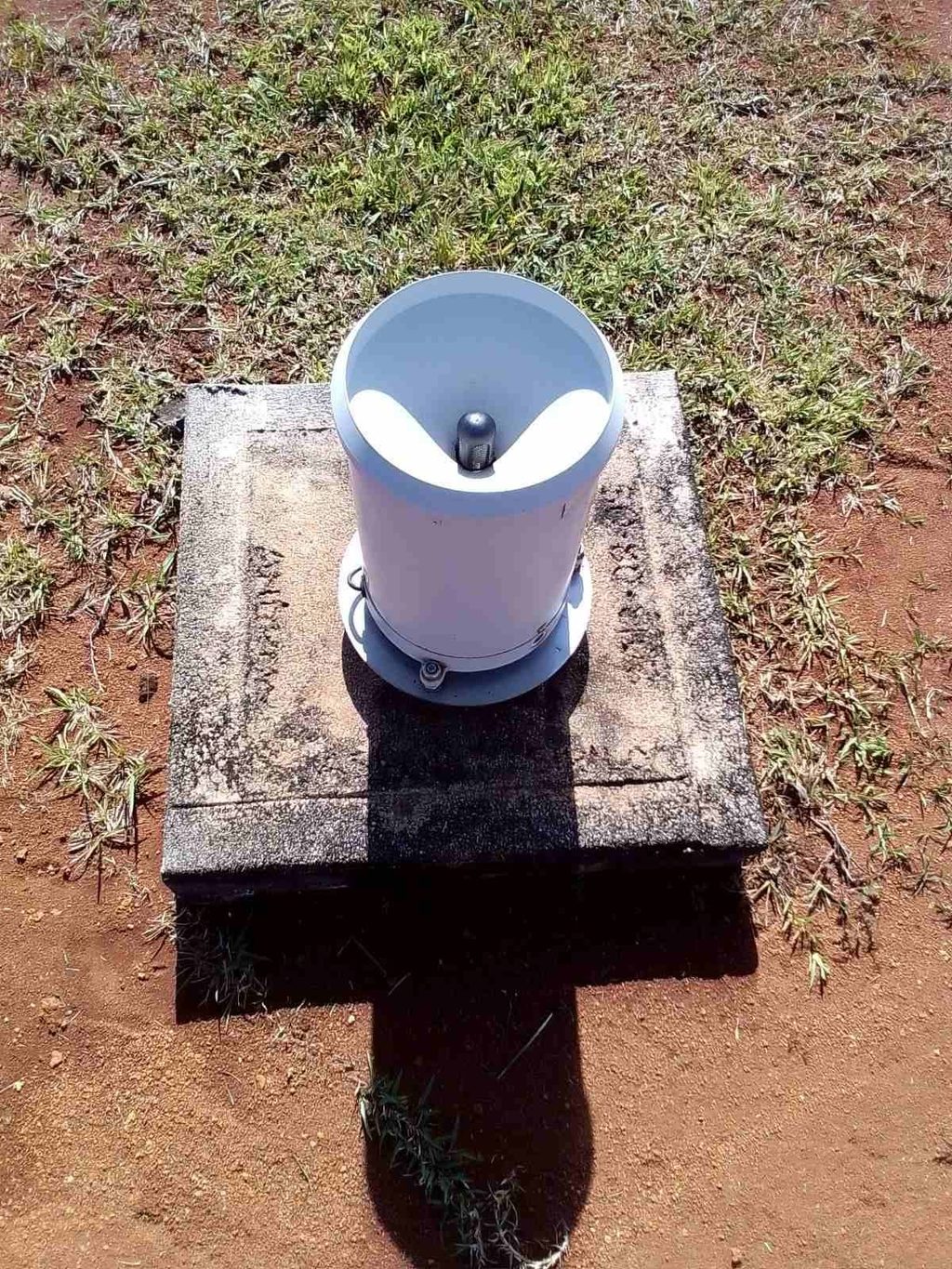
Tipping-bucket rain gauge located at the Nadarivatu Automatic Weather Station.
Picture: FIJI METEOROLOGICAL SERVICE/Facebook