In the South Pacific, Tonga is situated 30 kilometres south of Fonuafoʻou, a submerged volcanic island.
Tonga’s main island lies around 60 kilometres north of the site of the most recent volcanic eruption.
In fact, the Pacific tectonic plate is gently sliding under the Australian plate in a zone of subduction in the earth’s crust.
A well-known volcanologist (Janine Krippner) believes this area is situated along the Circum-Pacific belt, also known as the Pacific Ring of Fire, or a garland of volcanoes in the Pacific Ocean.
The subduction zone is the primary driving force behind this region’s volcanic activity; it is a region where tectonic limits are more favourable for the development of volcanoes.
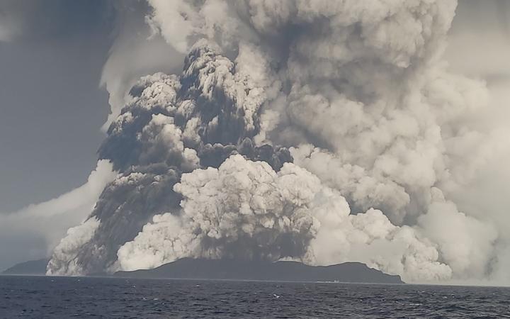
There are more active volcanoes in this region than anywhere else on the globe, and many of them are underwater (Fig.1). Hunga Tonga and Hunga Ha’apai are two tiny, nearby islands, where all that could be seen of this volcano until recently.

Understanding, why the explosion was so tremendous comes from the fact that the great portion of the volcano is underwater.
A phreatomagmatic eruption occurs when heated magma comes into contact with colder water and creates enormous steam, and although scientists don’t know precisely what happened, they do know that the boom was the consequence of this kind of eruption.
The explosion is thought to have happened around 150 feet below the surface of the ocean.
It is possible that the explosion might have been contained if these chemical processes had taken place in deeper water.
On the other hand, Dr. Krippner, a volcanologist argued that the water reaction alone could not account for the eruption’s great force and that more investigation was required to determine the sequence of events leading up to the explosion.
However, besides scientific evidences there are different beliefs and myths about the occurrences of volcanic eruptions.
Say for instance, the Greeks and Romans thought that there is an underworld God named Vulcan, and the explosions occur only when the Vulcan lit his underground hearth underneath the volcano, a tiny volcanic island in Sicily that gave its name to the current volcano.
Naturally, we have come to assume that this is no longer the case.
Volcanologists and geologists have established a significant link between volcanic activity and crustal disturbances, most notably zones of weakness induced by mountain folding and deep faulting.
Tonga’s volcanic outburst is now being seen in terms of a massive landslide, enabling saltwater to enter and interact with the magma.
It may be hard to figure out why the volcano erupted because the monitoring equipment that normally lets scientists see what’s going on inside the volcano was not easy to get to.
In a column somewhere between 35 and 40 kilometres high in the sky, the cloud is believed to have broken through the tropopause, which is the uppermost part of the troposphere.
For the majority of the Earth’s weather, this layer serves as a roof.
More than 400km by 400km of ash had been spread out within an hour after the eruption.
Although similar shock waves have been created by volcanoes and other meteorological occurrences in the past, the magnitude of this one has surprised experts.
According to data from the Bureau of Meteorology, the shock wave was travelling at a speed of almost 1000 kilometres per hour.
According to local officials, the eruption ejected ash, steam, and gas 12.4 miles into the air and had a radius of 161.5 miles.
The eruptions generated shock waves, sonic booms, and tsunami waves that could be heard in Alaska. An umbrella cloud of crescent-shaped shock waves generated because of the form of the plume of material.
The umbrella cloud had a diametre of 500 kilometres at its highest extent, which is equivalent to the Philippines’ Pinatubo.
This is according to Michigan Tech volcanologist Simon Carn.
Water’s inclusion in the Tonga eruptive process may have contributed to the eruption’s greater explosiveness than a purely magmatic event like the Pinatubo eruption.
Ten megatons of TNT were believed to have been released in the eruption.
Significant damage was done to the western shore of Tongatapu’s main island as a result of the explosion and subsequent tsunami.
The latest eruption has claimed the lives of two Tongans, and many more are still fighting the rubble.
As a result of the explosion, there is a risk that the water supply may become polluted. Because of the massive explosion, large waves and tsunami warnings were issued for the west coastlines of North and South America as well as Australia, New Zealand, and Japan.
The Japanese coasts were battered by nine-foot-tall waves, while the west coast suffered from waves of three to four feet high. At least two individuals were killed, and an oil leak was triggered by the high water in Peru.
Almost 90 per cent of volcanoes on the globe are not monitored for activity on a regular basis.
Furthermore, manual assessment is no longer feasible due to the vast amounts of satellite data presently accessible.
An automated detection technology was developed because of the requirement to reduce enormous volumes of data into useful information for timely eruption detection.
- MOHAMMAD AFSAR ALAM (PhD) is a assistant Professor of Geography, Dept. of Social Sciences, Fiji National University, Fiji. The views expressed are his own and may not necessarily reflect the views of this newspaper or his employers. For comments and suggestions, Email:
drmaalam92@gmail.com

