In a bold and transformative move towards modernising how Fiji assesses and manages its water resources, the government – through the Ministry of Lands and Mineral Resources, in partnership with Geoscience Australia – is preparing to launch the country’s first-ever Airborne Electromagnetic (AEM) survey.
This innovative project, scheduled to take place between June and December 2025, will cover key areas of Viti Levu, Vanua Levu and Taveuni.
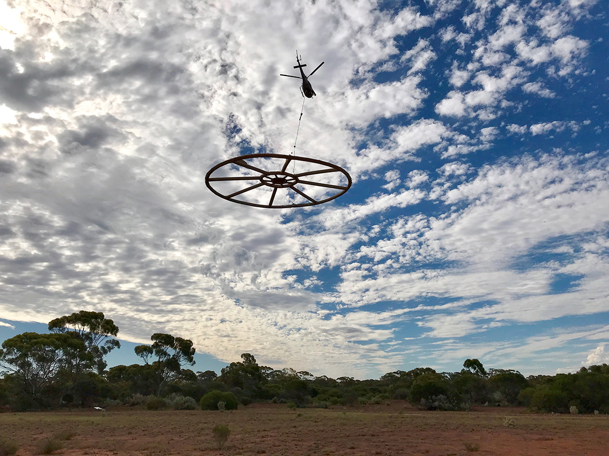
It marks the beginning of a new era of scientific precision and efficiency in groundwater exploration. Led by the Mineral Resources Department (MRD), the survey will utilise advanced geophysical technology to collect real-time data from the air. A helicopter, fitted with a large, coil-shaped sensor, will fly at a height of about 80 to 100 metres above the ground.
As it flies, the equipment will gather detailed information about underground water sources – without the need for widespread ground-based surveys.
“This project represents a significant leap forward in how we understand and manage one of our most vital resources – water,” said Minister for Lands and Mineral Resources Filimoni Vosarogo.
“It’s not just about technology. It’s about ensuring that every Fijian, no matter how remote their community, has reliable access to clean and safe water.”
What is Airborne Electromagnetic survey?
An airborne electromagnetic geophysical survey is an advanced, non-invasive method of mapping the Earth’s subsurface. The technology works by detecting the electrical conductivity of subsurface materials and structures using electromagnetic (EM) sensors (transmitter and receiver) mounted on aircraft. These sensors can identify water-bearing aquifers, trace groundwater flow paths, and even pinpoint areas where saltwater might be intruding into freshwater supplies.
The primary advantage of AEM is its efficiency. Unlike traditional two-dimensional surveys, which require labour-intensive manual methods, AEM can cover vast and often inaccessible areas quickly and with minimal environmental disturbance. This makes it especially useful in regions with difficult terrain, such as Fiji’s highlands and outer islands.
Nationwide coverage
The scope of the AEM survey is ambitious. In Viti Levu, it will cover regions like Lomawai-Momi, the Sigatoka Valley, Tavua, Namara/Verata, and Rakiraki. On Vanua Levu and Taveuni, the helicopter will traverse areas such as Dreketi/Seaqaqa, Tabia, Udu Point, Nadogo, and Wainikoro. Flight lines will be spaced approximately 500 metres apart for the two main islands and 5000 metres apart for Taveuni.
Communities in these areas can expect to see a helicopter towing specialised equipment in loops beneath it – a temporary and safe operation that the ministry assures poses no risk to public health or the environment.
Supporting Fiji’s National Development Plan
The introduction of AEM technology aligns directly with Fiji’s broader National Development Plan (NDP), particularly its goals of improving access to essential services such as water and sanitation. The government has long identified water security as a critical development challenge, particularly for rural and maritime communities that are not connected to the Water Authority of Fiji’s infrastructure.
Through this survey, the Ministry of Lands and Mineral Resources aims to build a robust database of groundwater resources, helping to inform the planning and delivery of new water systems. Better groundwater data means better borehole placements, more resilient infrastructure, and ultimately, fewer communities going without water during dry seasons or periods of drought.
“This is not just a scientific exercise,” said Mr Vosarogo. “This is a life-changing project for thousands of Fijians. With this data, the government can act with precision – delivering water where it’s needed most, faster and more sustainably.”
A collaborative effort
The initiative is a product of regional collaboration and technical assistance. Geoscience Australia is a key partner in the project, lending their expertise in geophysical surveys and data analysis. Support has also come from the Australian Government, reinforcing the Vuvale Partnership between Australia and Fiji.
“This project is a shining example of the Vuvale Partnership in action – Fiji and Australia working hand in hand to deliver practical solutions for our people. Through shared knowledge and regional cooperation, we are building a more resilient future where every Fijian has access to safe and reliable water,” said Mr Vosarogo.
Community engagement and transparency
Recognising that public awareness is crucial for the success of the survey, the ministry has planned consultations with local communities and settlements before the survey begins. These sessions aim to explain the purpose of the helicopter flights, reassure residents of the technology’s safety, and build community ownership of the process.
“We want to make sure people are informed, comfortable, and even excited about this development,” said Mr Vosarogo. “This is about them – about improving their access to water and their quality of life.”
Looking ahead
As climate change continues to impact water availability across the Pacific, Fiji’s move to embrace AEM technology underscores its commitment to innovative, sustainable solutions. The data generated by this survey will serve not only immediate needs but also guide long-term water management strategies.
It also sets a precedent for other Pacific Island nations looking to modernise their approach to groundwater exploration and resource management.
“We are not just flying over land – we are soaring into the future. This technology gives us eyes beneath the surface and the foresight to plan better for our people. It’s a historic first for Fiji, and the benefits will be felt for generations to come,” said Mr Vosarogo.
As the humming of survey helicopters begins to echo across Fiji’s skies later this year, it will carry with it a message of progress, innovation, and hope – one that promises a future where every Fijian, regardless of geography, has access to one of life’s most basic and vital resources.

