A storm warning is now in force for Yasawa and Mamanuca Groups, Western and Northern Viti Levu, while a gale warning is now in force for Rotuma, western Vanua Levu (Dreketi, Bua to Savusavu), eastern Viti Levu and Lomaiviti Group.
According to the Fiji Meteorological Service, damaging cyclone related winds are imminent in these locations within the next 24 hours.
The weather office says a storm alert is in force for Southern Viti Levu, Vatulele, Kadavu and nearby smaller islands.
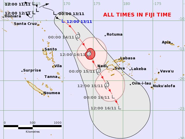
“Tropical depression, TDO2F, was located approximately 700km West-Northwest of Rotuma or around 1000km Northwest of Yasawa-i-rara at 3pm today.
“It is expected to strengthen into a tropical cyclone later this evening.
“The current projected path indicates that the system will approach the Fiji Group on Tuesday as a Category 2 system and continue its journey through the country on Wednesday and then gradually weaken.
The path of the system is expected to pass close to the west of Viti Levu with storm force winds over the Yasawa and Mamanuca Groups, western and southern Viti Levu, Vatulele, Kadavu and nearby smaller islands.
“However, it is a huge system and its effect can be far reaching. Consequently, Gale Warning is in force as far as western Vanua Levu (Dreketi, Bua to Savusavu), eastern Viti Levu and Lomaiviti Group.
“These winds can break tree branches, blow unsecured and loose materials, disrupt communication network and power supply due to damaged power lines, damage temporary and weak structures, increase the risk of sea travel for all types of sea crafts, and increase the risk for hazardous breaking waves and coastal inundation of debris along low lying coastal areas, especially during high tides.
The cyclone may begin to have an impact on the Yasawa and Mamanuca Groups from later tomorrow morning.
While the system is expected to begin to affect Viti Levu from later tomorrow afternoon, most of the destructive winds are expected overnight on Tuesday and into early morning on Wednesday. Thus, public are advised to do as much preparatory work today and by early morning tomorrow during the daylight hours.”
The Fiji Met says the trough of low pressure associated with TD02F is already bringing a lot of rainfall over the country, especially over the Northern, Eastern and Central Divisions.
“Consequently, a flash flood warning is in force for Ovalau and parts of Suva, and flash flood alert is in force for a number of areas in southern Vanua Levu, parts of the Central Division, especially Tailevu and Naitasiri, and Koro Island.
“Periods of rainfall, heavy at times is likely over the Fiji Group until early Wednesday. Consequently, a heavy rain warning is in force for whole of the Fiji Group.
“High tides are expected at around 6pm tonight, 7am tomorrow morning and 7pm tomorrow evening.
“For mariners and seafearers, expect gale force winds with speeds of 35 to 45 knots, gusting to 55 knots over Vatu-i-Ra Passage, Yasawa, Mamanuca, Kadavu Passage, Koro Seas and Northern Vanua Levu waters from tomorrow morning, which is likely to further increase to storm force winds with speeds of 50 knots and gusting to 70 knots from tomorrow afternoon.
“For the rest of Fiji waters, expect gale force winds with speeds of 35 to 45 knots, gusting to 55 knots from tomorrow afternoon. Seas are expected to be rough to very rough, becoming high to very high seas from tomorrow.”
Click on the link for latest updates: https://www.met.gov.fj/index.php?page=warn1#20020.txt

